Select your language

Italian National Agency for New Technologies, Energy and Sustainable Economic Development
ENEA Atlas for development cooperation

Earth observation technology (EOT) applied to archaeological heritage and georesources protection

For achieving the objectives:
goal 11
goal 13
goal 14

Description

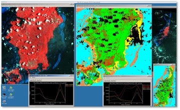
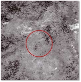
ENEA’s expertise is put at disposal for image processing and radar and optical images classification procedures applied to the study of local phenomena for the management and protection of archaeological heritage, natural resources (surface and phreatic water, land use) and emergencies (earthquakes, floods, historical centres vulnerability).

Satellite multispectral data processing through the analysis of the related forms and processes allows to produce thematic cartographies for the rational management of the landscape.

Benefits and advantages:

  • Landscape scenarios for planning
  • Response to emergencies
  • Capacity building
  • Creation of economic activities;

ENEA Service:

  • design
  • technology transfer
  • training

ENEA Activities:

Sectors

410 - General Environment Protection
41040 - Site preservation

SDGs Target

11.4 Strengthen efforts to protect and safeguard the world’s cultural and natural heritage
Landsat 7 image (USGS) of the Palau Archipelago (Pacific Ocean) for the automated classification and extraction of land cover spectral signatures
SPOT 5 satellite panchromatic image (SpotImage) in Mongolia, highlighting round shapes in the desert which can be related to ancient burial sites (Immordino F., Marcolongo B., 2009, A la recherche de tombes impériales. SPOT magazine n. 46, 1er semestre 2009, pp. 18-19.)

Refecences

Department for Sustainability

Contacts

Published: 29/04/2020
Feedback